
The installation of NOAA’s Physical Oceanographic Real-time System (PORTS®) at Pearl Harbor-Honolulu, Hawaii, marks a significant advancement in maritime safety and navigational reliability within the Pacific Islands. This system, known for enhancing safety and efficiency at numerous U.S. seaports, is now positioned to play a vital role in Hawaii’s maritime activities. As the 40th installment in NOAA’s expansive PORTS network, this system emerges from a collaboration with the U.S. Navy, aimed at improving navigation around Pearl Harbor and Joint Base Pearl Harbor-Hickam, locations that hold substantial economic and strategic importance.
Enhancing Safety and Navigation
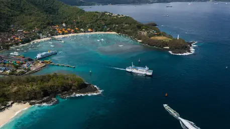
Real-time Monitoring and Data Collection
The real-time data provided by PORTS has the potential to redefine maritime safety and operational efficiency in the busy waters of Pearl Harbor and Honolulu Harbor. With accurate, up-to-the-minute information on water levels, wind conditions, and tidal currents, both commercial and local mariners are equipped to make well-informed navigational decisions. This data is crucial for optimizing cargo loading and reducing potential delays, ensuring that the bustling port, which handles over 11 million tons of cargo annually, functions with maximum efficiency. Additionally, the National Weather Service in Honolulu integrates this data to forecast coastal flooding, allowing for preventative measures and minimizing risks associated with extreme weather conditions.
The system includes meticulously placed monitoring equipment, such as a water level and meteorological station on Ford Island and a buoy-mounted current meter at Ford Island Channel. The data captured encompasses essential meteorological elements such as wind speed, air temperature, and atmospheric pressure, all of which are critical for managing operations safely amidst high ship traffic. The integration of this real-time information can significantly alleviate the challenges posed by adverse weather, thereby safeguarding both human lives and cargo.
Supporting Naval and Commercial Operations
The installation of PORTS at Pearl Harbor extends its support to naval operations, enhancing the overall planning and monitoring processes during both routine activities and extreme weather events. With precise monitoring of marine conditions, naval operations can proceed with increased assurance, thus improving the overall safety of personnel and assets. The system’s collaboration with U.S. Navy Region Hawaii further emphasizes its strategic significance, particularly in a location where military and commercial activities are densely intertwined.
Moreover, the data provided by PORTS allows for improved coordination among various maritime stakeholders, reducing the likelihood of accidents and disputes over maritime space. Pearl Harbor and Honolulu Harbor, with their complex intermingling of commercial, leisure, and military activities, benefit immensely from the streamlined and synchronized flow of information. This level of data integration ensures that sailing routes are safely navigated, and any potential hazards are promptly communicated and addressed.
Economic and Environmental Benefits
Protecting Coastal Economies
Honolulu Harbor’s role as Hawaii’s main seaport highlights the economic importance of PORTS, which safeguards not just maritime operations but also the broader state economy. By optimizing the movement of vessels and minimizing delays, the system enhances the harbor’s operational efficiency, directly affecting the economic activities linked to the vast cargo throughput. As this harbor significantly contributes to the region’s economic vitality, ensuring its optimal operation through advanced monitoring is paramount.
Moreover, the timely data dissemination regarding water levels and potential flooding provides added security against climate-related adversities, protecting both the infrastructure and investments along the Hawaii coastline. With coastal flooding becoming an increasing concern, the integration of PORTS data into broader climate response strategies can mitigate potential economic setbacks, ensuring that weather-related disruptions have minimal impact on critical harbor operations.
Environmental Considerations
Environmental impacts also come into play as PORTS contributes to sustainable marine operations around Hawaii. With real-time information aiding in the optimization of shipping routes and timing, fuel efficiency can be improved, which translates to a reduced carbon footprint for maritime operations. Furthermore, the system plays a role in preventing potential environmental incidents through its timely warnings, thus safeguarding marine habitats from pollution and ecological disruptions.
The collaboration between advanced technology and environmental awareness embodied in PORTS means that Hawaii’s seaports are not only safer but are also aligned with modern sustainability principles. With maritime safety being directly linked to the protection of fragile marine ecosystems, PORTS serves as both a functional and ethical tool in managing resources effectively.
Perspectives for the Future
Commitment to Long-term Maintenance
The implementation of PORTS at Pearl Harbor is not only a testament to technological innovation but also a demonstration of NOAA’s commitment to ensuring long-term operational integrity through meticulous maintenance. By securing a robust system built on public-private collaboration, the presence of PORTS in Hawaii is designated to remain a cornerstone of maritime safety and efficiency for years to come. Backed by documented outcomes of reducing maritime accidents by half in areas using such data, the reliability and effectiveness of the PORTS framework are undisputed.
The continued success of PORTS in Hawaii will likely strengthen its role as an essential infrastructure component in supporting dynamic economic growth and safeguarding lives. As maritime operations worldwide increasingly acknowledge the value of such systems, PORTS not only exemplifies enhanced safety and operational planning but also sets a precedent for integrating advanced technology with regional development strategies.
Broadening Horizons
The recent installation of NOAA’s Physical Oceanographic Real-time System (PORTS®) at Pearl Harbor-Honolulu, Hawaii, represents a significant leap forward in maritime safety and navigation for the Pacific Islands. Known for bolstering safety and efficiency at numerous U.S. seaports, this sophisticated system is poised to play a crucial role in Hawaii’s maritime operations. As the 40th addition to NOAA’s extensive PORTS network, this system has emerged through collaboration with the U.S. Navy. Its primary focus is enhancing navigation around Pearl Harbor and Joint Base Pearl Harbor-Hickam, sites of notable economic and strategic importance. PORTS® provides real-time oceanographic and meteorological data, assisting mariners with critical information that aids safe passage and operational planning. This collaboration not only ensures smoother navigation but also supports the Navy’s strategic needs, fortifying Pearl Harbor’s role as a vital hub in both military and commercial sectors.