
A digital shadow falls over physical assets when a cyber threat breaches the boundary between corporate networks and industrial controls, turning harmless code into a physical hazard. This intersection of digital data and physical machinery represents one of the most significant security challenges of the current decade, as the traditional barriers that once protected critical infrastructure have dissolved. Modern organizations no longer operate in silos where Information Technology and Operational Technology function as separate entities. Instead, a new reality has taken hold where the demand for real-time visibility and efficiency necessitates a deep, integrated connection between business intelligence and mechanical execution. Within this high-stakes environment, Geographic Information Systems serve as the foundational map that allows security professionals to visualize, monitor, and defend the perimeter where bytes meet breakers.
The necessity of this convergence stems from a fundamental shift in how global infrastructure is managed and maintained. Historically, utility grids, water systems, and transportation networks relied on the physical isolation of their control systems to ensure safety. However, the requirement for data-driven decision-making and the pursuit of decarbonization goals have made this isolation a relic of the past. To manage a modern smart city or a renewable energy grid, data must flow seamlessly from individual sensors at the edge to centralized enterprise applications. This flow creates a complex web of vulnerabilities that traditional security models struggle to address without the spatial context provided by advanced geospatial platforms.
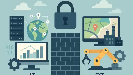
The Invisible Bridge in a Hyper-Connected Infrastructure
The concept of the “air gap”—once considered the gold standard for industrial security—has officially been declared obsolete in the face of modern operational requirements. In an era where utility grids and transportation networks must respond to fluctuating demands in real time, the physical isolation of Operational Technology from business Information Technology has become a bottleneck for progress rather than a safeguard. This transition toward hyper-connectivity forces a total reimagining of the digital perimeter. Organizations now face a persistent paradox: they require total connectivity to drive operational efficiency and sustainability, yet every new sensor or gateway provides a potential point of entry for malicious actors seeking to disrupt essential services.
As these two worlds collide, the role of data becomes more than just a reporting tool; it becomes a defensive asset. The bridge between the office and the plant floor is no longer a physical cable but a continuous stream of telemetry that must be validated and secured. In this landscape, security is not merely about blocking unauthorized access but about understanding the relationship between digital activity and physical consequences. By utilizing spatial data to map these connections, technology leaders can identify which digital assets correspond to critical physical components, creating a more resilient framework that treats the entire infrastructure as a single, unified organism rather than a collection of disconnected parts.
The integration process also uncovers the hidden risks inherent in legacy systems that were never designed to be online. Many industrial components currently in operation were built decades ago with a focus on longevity and reliability, not cybersecurity. Bringing these assets into the connected ecosystem requires a sophisticated oversight mechanism that can interpret their behavior within a geographic context. Without such a framework, a digital anomaly in a remote substation might be overlooked until it manifests as a physical failure, highlighting the critical need for a security layer that provides both digital oversight and physical awareness across the entire enterprise.
Why the IT/OT Convergence Demands a New Security Paradigm
The shift toward comprehensive digital transformation has fundamentally altered the methodology used to manage and protect physical assets across all industrial sectors. Historically, the division of labor was clear: Information Technology handled data management, business communications, and financial records, while Operational Technology focused on the specialized hardware, such as pumps, valves, and electrical breakers. This binary model allowed each side to develop its own specialized security protocols, but the modern need for real-time analytics and artificial intelligence-driven predictive maintenance has rendered the traditional disconnected model completely ineffective for modern operational needs.
By connecting industrial control systems directly to enterprise networks, organizations inadvertently expose their most critical infrastructure to the same sophisticated threats that plague the digital world, from ransomware to state-sponsored intrusions. This expanded attack surface means that a vulnerability in a corporate email system could theoretically provide a pathway to a water treatment plant’s chemical dosing controls. Consequently, security can no longer be viewed in a vacuum. Technology leaders now require a spatial system of record to provide the necessary context to understand where a threat is occurring in relation to the physical environment, allowing for a more targeted and effective response to potential breaches.
Furthermore, the language used by IT professionals often differs significantly from that used by OT engineers, leading to a communication gap that can be exploited during a crisis. IT focuses on data confidentiality and integrity, whereas OT prioritizes availability and safety above all else. A security paradigm built on geospatial integration helps bridge this gap by providing a common visual language. When both teams can see a threat developing on a map that displays both the network topology and the physical asset location, they can collaborate more effectively to mitigate risks without compromising the safety of the mechanical systems or the employees working on the front lines.
Leveraging GIS as the Unifying Security Layer
Geographic Information Systems serve as the essential bridge between the digital and physical domains, providing a common spatial language for both IT and OT professionals to communicate and collaborate. By anchoring telemetry from thousands of remote sensors to specific, verified geographic locations, GIS allows operators to maintain a single, integrated view of their entire infrastructure. This unified visualization creates situational awareness that is impossible to achieve through traditional dashboards alone. When a security alert triggers, operators do not just see an IP address; they see a specific asset on a map, its proximity to other critical components, and the potential physical impact of a system failure in that specific zone.
The operational coordination facilitated by these systems ensures that the information moving across the IT/OT boundary is accurate and spatially verified. For instance, GIS technology allows for the synchronization of field data from mobile devices with centralized enterprise applications, ensuring that maintenance crews and security analysts are looking at the exact same set of facts. This spatial metadata is a powerful tool for risk mitigation, as it helps analysts quickly identify the geographical scope of a cyber-physical threat. If a digital anomaly is detected, security teams can correlate that data with physical access logs at a specific substation to determine if the threat is purely digital or if it involves a physical breach of the facility.
In the utility sector, organizations are already utilizing these spatial frameworks to manage the entire asset lifecycle, from the initial permitting and design phases to real-time outage management and decommissioning. Companies such as TRC have demonstrated how GIS can be used to track every piece of hardware across a massive service territory, ensuring that security protocols are applied consistently to every asset regardless of its location. Similarly, in the realm of sustainable portfolio management, firms like Verdani Partners are merging building performance data with environmental risk factors. This approach allows them to implement secure, data-driven decarbonization strategies across global real estate portfolios by using geospatial analytics to monitor energy consumption and environmental impacts in a secure, centralized environment.
Expert Perspectives on the “Security-by-Design” Mindset
Leading security architects and industry researchers have reached a consensus that the integration of these systems must be proactive and built into the architecture from the beginning rather than being treated as a reactive addition. This mindset has led to the widespread adoption of the Zero Trust model, which operates on the principle of “never trust, always verify.” Experts argue that in a converged IT/OT environment, trust should never be granted based on network location or device type. Instead, identity-centric security ensures that every request for data or control is verified through robust Identity and Access Management protocols, providing granular permissions that adjust based on real-time risk assessments.
The role of edge computing has also become a central topic in expert discussions regarding the protection of the industrial perimeter. By processing data locally at the site of the OT asset and using encrypted application containers for transmission, organizations can prevent a localized compromise from spreading through the entire enterprise network. This decentralized approach ensures that if one controller is compromised, the breach remains contained, allowing the rest of the system to continue functioning safely. This strategy is becoming increasingly important as the IT/OT integration market is projected to reach a staggering $8.61 billion by 2033, driven by the need for more resilient and intelligent infrastructure management.
Industry leaders emphasize that organizations failing to adopt these integrated, security-by-design models will face not only operational risks but also significant financial and regulatory obsolescence. As international security standards evolve to demand greater transparency and resilience, the ability to demonstrate a secure, spatially aware management system becomes a competitive necessity. The move toward this integrated future is no longer a choice for forward-thinking executives; it is a fundamental requirement for maintaining public trust and ensuring the long-term viability of critical services in an increasingly volatile global environment.
Strategies for Maintaining a Robust Digital Perimeter
To effectively secure the boundary between IT and OT, technology leaders must implement a series of rigorous engineering best practices designed to restrict unauthorized movement while allowing for essential data flow. One of the most effective strategies is the implementation of microsegmentation, which involves creating small, isolated zones within the network. By restricting direct connectivity between OT controllers and general business applications, organizations can prevent the lateral movement of attackers who might gain access through a less secure part of the enterprise. This ensures that even if a corporate workstation is compromised, the attacker has no direct path to the critical industrial control systems that manage power or water delivery.
The deployment of specialized hardware, such as secure gateways and data diodes, further strengthens the perimeter by enforcing one-way data flows. These devices allow sensitive OT data to be sent to enterprise analytics platforms for monitoring and optimization without allowing any external commands to travel back to the critical controllers. Additionally, enforcing universal encryption for all data, both at rest and in motion, is essential for protecting telemetry coming from edge devices. These edge components are often the most vulnerable points in the supply chain, and ensuring that their communications are encrypted prevents attackers from intercepting or tampering with vital operational signals.
Finally, the utilization of pattern-based anomaly detection systems allows organizations to recognize what constitutes normal industrial behavior. By identifying subtle deviations in operational patterns through GIS-linked monitoring, systems can flag hardware malfunctions or cyber-intrusions long before they result in a total system failure. Engaging with specialist consultants who understand the complexities of merging spatial data with industrial controls is also a vital step in ensuring that the resulting architecture remains scalable and compliant with evolving global standards. Through these combined efforts, the boundary between the digital and physical worlds becomes a resilient shield rather than a vulnerable gap.
The implementation of these strategies was essential for organizations that sought to bridge the gap between their corporate offices and industrial sites. Technology leaders recognized that spatial intelligence served as the most effective tool for managing the risks associated with hyper-connectivity. The industry moved toward a model where every asset was tracked, every data flow was encrypted, and every identity was verified. Engineers utilized microsegmentation to ensure that localized failures did not cascade into regional disasters. Security teams successfully integrated geospatial metadata into their defensive workflows, allowing them to respond to threats with unprecedented speed and accuracy. These actions established a new standard for infrastructure resilience that prioritized both efficiency and safety in a unified framework. Organizations that adopted these spatial security models were able to navigate the complexities of the digital age with greater confidence. The transition from reactive defense to proactive, location-based management proved to be the most effective way to secure the vital services upon which society depended. By the time these integrated systems became the industry norm, the boundary between IT and OT had been transformed into a secure, transparent, and highly efficient channel for innovation. Ultimately, the successful convergence of these domains was achieved through a commitment to security-by-design and a deep understanding of the physical world.